Herzman to Camp Freeman Project
Learn about the Herzman to Camp Freeman Project on the Cedar River. As the project is developed, opportunities for public input will be published here.
Project overview
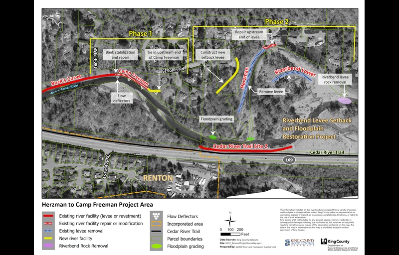
The Herzman to Camp Freeman Project will reduce flood and erosion risk along a half-mile stretch of the Cedar River. The project area runs along the right bank of the river, when looking downstream, between Renton and Maple Valley. It is about four miles east of the I-405/SR 169 interchange in unincorporated King County.
The King County Flood Control District with King County, as service provider, is implementing the project in two phases. Phase 1 will be constructed first and will repair the Buck’s Curve and Camp Freeman revetments at the downstream (eastern) end of the project. Phase 2 focuses on the removal and setback of the lower Herzman and Riverbend levees.
The 2017 Cedar River Capital Investment Strategy identified the need for the project.
The project area includes the Herzman Levee, Camp Freeman Revetment, and a portion of the Buck’s Curve Revetment along the right bank of the river, when looking downstream. These facilities reduce flood risks to several homes and to S.E. Jones Road.
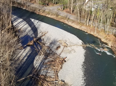
A major flood in February 2020 caused the river to quickly change course in the project area and break through the Riverbend Levee upstream. The river then cut through the former Cavanaugh Pond location. There was also damage to the upstream end of the Buck’s Curve revetment along S.E. Jones Road.
Damage also occurred at the furthest upstream portion of the Herzman Levee that protects S.E. Jones Road, reducing the stability of the revetment. The main river channel no longer runs along the Herzman Levee.
The project team has evaluated the site conditions and drafted construction plans to repair Buck’s Curve Revetment and the Camp Freeman Revetment. An upstream segment of the Camp Freeman Revetment will be buried underground. Both repairs will help reduce the risk of flood damage to S.E. Jones Road.
The Riverbend Levee Setback and Floodplain Restoration Project stabilized another nearby revetment in 2022. The projects are working together to maximize flood risk reduction and habitat benefits.


Project goals
- Repair damaged revetments to reduce erosion risks to SE Jones Road and nearby homes.
- Remove the Herzman Levee and replace it with a smaller levee to reconnect the river with its floodplain and help natural habitat to form.
- Combining efforts with the Riverbend Levee Setback and Floodplain Restoration Project to achieve other social and environmental benefits.
Project schedule
| Activity |
Date |
|---|---|
| Planning, acquisitions, and alternatives selection |
2017 to 2023 |
| Phase 1 anticipated final design and permitting | 2024 to 2025 |
| Phase 2 anticipated design and permitting | 2025 to 2026 |
| Phase 2 anticipated construction |
2027 |
| Post-construction S.E. Jones Road paving completed |
2028 |
Additional information
Project sponsors
The alternatives analysis and preliminary design of the project were funded by a Floodplains by Design grant from the State Department of Ecology. Subsequent phases of the project, including final design and construction, will be funded by the King County Flood Control District, partner agencies, and grants.
 Translate
