
 Translate
Snoqualmie Valley Major Flood Mitigation Study (Cross Valley)

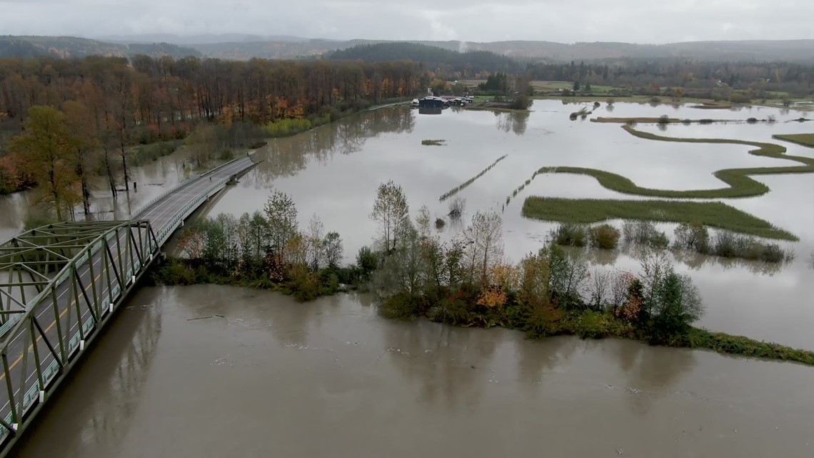
Flooding around the Snoqualmie river after heavy rains moved into the area on Oct. 22, 2019, on NE Tolt Hill Road. Photo: King5
Overview
This study looks at different ways to reduce or eliminate traffic problems caused by flooding in the Snoqualmie Valley. It focuses on keeping at least one of four existing roads and bridges that cross the Snoqualmie River open during floods rather than solving the flooding itself. The county and our partners began the Cross Valley study in December 2022. The first phase was completed in October of 2024.
Keeping key routes open
The four major roads and bridges that cross the valley and the Snoqualmie River are used by about 25,000 vehicles daily.
The study focuses on the four east-west roads and bridges over the Snoqualmie River between Duvall, WA and Carnation, WA. During floods, these four roads often close, cutting off important routes and isolating communities. From north to south:
- NE Woodinville Duvall Road
- NE 124th Street/Novelty Road
- NE Carnation Farm Road
- NE Tolt Hill Road

Impact of Flooding
Floods happen almost every year. High water can damage homes and close roads, making it hard for people to get around. Farms are also affected, which can hurt farmers financially. In addition, floodwaters can also change the river’s shape and flow, leading to more environmental and infrastructure challenges when roads or utilities are impacted.
Project partners
Those working on the study include:
- King County Road Services Division
- King County Flood Control District
- King County Water and Land Resources Division
When government partners work together on a study, we can achieve much more than if we worked alone. Combining our resources, like money, knowledge, and skilled workers, allows us to do bigger and better research while being responsible stewards of public funds.
Additional benefits:
- Each partner brings its own expertise, which helps create well-rounded and accurate results.
- Sharing our data makes the findings more reliable.
- Creates consistent policies and avoids conflicts.
Topics covered in the study
The study will explore 12 main topic areas to recommend ways to keep traffic moving in the Snoqualmie Valley. The goal is to use what we learn to come up with practical solutions to manage traffic and reduce road disruptions during floods.
Design and Engineering
- Bridges and Culverts: Looking at how to design and build bridges and culverts (structures that allow water to flow under roads) that can handle both traffic and strong water flows.
- Traffic: Studying how vehicles move through the area to design roads that reduce traffic jams, improve safety, and keeps goods and people moving.
- Construction Options: The team will look at how difficult each proposed option is to build and how much each option will cost.
Environmental Considerations
- Soil and Ground Stability: Experts will check the stability of soil, and water flow to make sure roads and bridges are built safely and can withstand and resist floods and slides.
- Water Flow (Hydrology and Hydraulics): Studying how water moves in rivers, streams and pipes. This will help us to design bridges and culverts that will manage water well during floods.
- Environmental Impact: Reviewing how construction might affect nature, including plants, animals, and water quality. This will help make sure that roads and infrastructure are built in a way that minimizes impact to the environment and meets current regulations.
Mapping and Land Use
- Mapping and Surveying: Creating maps and measuring land to guide where roads, bridges, and buildings should go.
- Land Use and Zoning: Understanding how the land is used for different things, like homes, farms, businesses, and following zoning laws to figure out where roads can go and how they affect local communities.
Community and Land Concerns
- Cultural Resources: Ensuring construction doesn’t damage historical sites, landmarks, and places that are important to Native American heritage.
- Land Ownership (Real Property): Finding out who owns the land where construction will happen and making arrangements to buy or use the property if needed.
- Community Outreach: Talking with local residents and communities to inform them about upcoming projects and get their input. This helps make sure the community’s concerns and needs are considered during planning and construction.
Project phases and timeline
Phase 1: Feasibility Study (December 2022 to October 2024)
- The team analyzed the four major roadways that cross the Snoqualmie Valley to learn which two roadways are most practical and likely to succeed. This phase helped decide which two roadways were the best roadways to move forward to Phase 2 of the study.
Phase 2: Review Options (24 months)
- The team will compare the two recommended options from phase 1 to help reduce the impacts to traffic movement during times of flood.
- In this phase, the project team will share what they learned in phase 1 with other government agencies.
- The community will be involved and will be asked to share feedback about the options during this phase.
- The team will select one road that will move forward to phase 3.
- Identifying funding for phase 3 of the project.
Phase 3: Preliminary Design (dependent on funding availability)
- This phase involves a lot of planning and checking to make sure everything will work as expected from the previous phases. The goal is to have a clear and practical design that can be used to start the design phase and better protect our roads from floods.
Budget and funding sources
King County Flood Control District provided $1,000,000 to fund Phase 1 and part of Phase 2 of the Feasibility Study. Further funding will be needed to complete Phase 3.
Community involvement
King County will do the following:
- During phase 2 of the study, the community will be asked to provide feedback about the improvement options.
- Provide updates on X/Twitter (@KCroads) with any project milestones.
- Send email notices. Subscribe to the Snoqualmie Cross Valley Study list to receive email or text message updates.
- Update this project website when opportunities for the public to get involved become available.
Growth of area
In the late 1800s and early 1900s, the valley was a big logging area. Early roads were just rough trails to move logs from the forests to sawmills and towns. These trails often followed rivers or ridges, making it easier for horse-drawn wagons and early trucks to get through.
Railroads were also important for the valley. By the late 1800s, Seattle, Lake Shore and Eastern Railway built a line through the valley, connecting Seattle to the timberlands. Some of today’s roads follow these old railroad routes. When the railroads weren’t needed for logging anymore, some routes became roads for local communities.
As towns like Snoqualmie, North Bend, and Fall City grew, the road system expanded. Paved highways, like State Route 202, replaced the old dirt and gravel roads, making it easier to travel to places like Seattle and Issaquah. Today, while many roads are used by commuters and tourists, the history of logging and railroads is still a big part of the valley’s character.
The Snoqualmie Valley is now home to around 56,000 people and is still known for its agricultural land and forestry. The fertile land in the valley is prone to flooding, especially from the Snoqualmie River.
Frequently asked question
Because our funding is limited, we’ve broken this work into three phases, and this adds additional time to the project. Creating options to help keep traffic moving across the valley during a major flood is complicated and needs careful study and analysis. Through the feasibility study, the team considered all the impacts of each of the four roadways, reviewing significant amounts of data, and many different considerations including soil, engineering, land use, and environmental with our internal groups and other partners in the community. The team is working as fast as possible while being thorough and diligent.
There isn’t another road where a fifth bridge could be built. The land where a fifth crossing could be built is not designated for roads or bridges. It is more cost effective to improve an existing road crossing the valley.
Raising any road would be extremely expensive. The County has a very limited budget and cannot currently afford to raise any of the existing roads.
The roads in the Snoqualmie River Valley have a rich history. Long before cars and modern roads, Native American tribes used footpaths to travel through the valley. These paths followed natural routes along the river and through the forests. Later, as settlers arrived and the area grew, some of these footpaths were turned into roads. In other parts of the valley, railroads were built to move timber and other goods. After the railroads were no longer needed, some of the old railroad routes were converted into roads that we still use today. Many of the current roads in the Valley were built before our current road design and construction standards.
At the end of phase 2 and after input from cities, community partners, and the community, King County will identify the preferred option. Once the preferred option is selected and the funding is secured, engineers will begin the design process. We are actively seeking state and Federal funding sources for the design.
Photos

On January 7, 2009, a rainstorm hit the Snoqualmie River Valley. Heavy rain and melting snow from December 2008 caused the Snoqualmie River near Carnation to rise to 62.31 feet Photo: King County iMap.

On December 5, 2023, a storm caused flooding in the Snoqualmie Valley on NE 80th Street. It rained heavily for several days because of an atmospheric river, which made the rivers overflow and flood the area.